What Wildbook should this feature be in?
Jaguar
What would you like to see?
For jaguars it would be great if matching could be limited by distance from the current encounter. Jaguars generally don’t move more than 100 km so matching could be restricted to a radius of about 200 km around a current encounter (200 could be a default but the user should be able to select other values or enter a value in a textbox). The current filtering by geographic tags is more complicated to implement on the data side and there are issues with where to draw boundaries in continuous landscapes (jaguars in the boarder region between Peru and Bolivia for example can easily move between the two countries).
How would this functionality help you?
This functionality would not only speed up matching by reducing the encounter to compare, it would also eliminate matches that are biologically implausible.
Hi there! Thanks for taking the time to post this. I’d like to dig in a bit more, if you don’t mind.
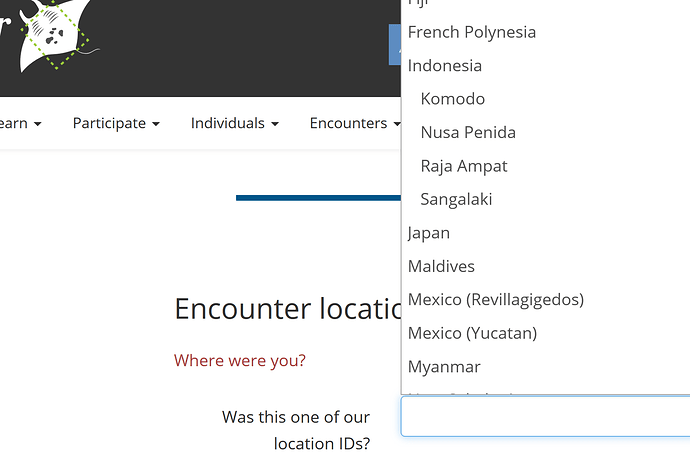
When looking at the jaguar platform, it seems like LocationIDs aren’t displaying any option other than Peru. We are able to set this up to represent a hierarchical listing of locations. I’ve included a screenshot from our MantaMatcher platform that displays how three regions of Indonesia roll up to Indonesia, allowing for as granular of a location selection as the reporter is comfortable with.
When leveraging LocationID, you can select multiple locations to filter on when doing a search, so the boundaries between countries shouldn’t be an issue.
If we had a list of locations that are applicable to the expected regions for jaguar reporting, it seems like that would meet a lot of the needs you’re trying to get at. Does that sound right?
Hi Tanya,
Yes, locations could work but they would have to be quite specific to be useful and would depend on local knowledge of the area as far as the names go. In the Indonesia example your locations are whole islands, in our example locations would not necessarily be geographically defined regions but more study sites.
I discussed this with Jason this week and we both thought that a distance based filter would be more flexible and should be fairly easy to implement since we store coordinates for all encounters (if coordinates are not available one could fall back to the LocationID). This will become even more important if we include smaller carnivores such as ocelots that move smaller distances but where there will be a large number of of individuals at each site.
Happy to discuss more.
Mathias
That’s all really great context. Are study sites well-known, or are those really only valuable to the individuals who work on a given site?
Regardless, it does sound like having a method that bridges human-defined boundaries would improve your workflow substantially.
Would the default value you propose, 200km, be something that is general to a given species? Or is it likely that you would have a different expectation of the animal’s range than another researcher? For example, would jaguars in different regions have different ranges?
Some study sites are well known, others are not. However, in many cases there is not natural geographic delineation. For our projects we can easily add study sites, but that does not mean that others would use the same definition of a study site, even if working in the same region.
As for the radius, looking at a map I think 150 km would be a good default for jaguars in most region, but yes, in some cases one might want a smaller or larger value. From a UI point of view I would use a text box that comes pre-populated with 150 but allows the user to enter other values. Sometimes one might want to increase the search radius to check for long-distance migrations which are possible.
